


plateau d ambel

JACQUES.FUMAT
User

Length
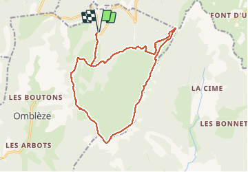
18.7 km

Max alt
1501 m

Uphill gradient
620 m
Km-Effort
27 km

Min alt
1134 m

Downhill gradient
620 m
Boucle
Yes
Creation date :
2018-04-17 10:07:47.259
Updated on :
2018-04-17 10:07:47.259
5h22
Difficulty : Unknown

FREE GPS app for hiking
 SityTrail
IGN / Geographical institutes
SityTrail Plus
The world is yours!
About
Trail Walking of 18.7 km to be discovered at Auvergne-Rhône-Alpes, Drôme, Omblèze. This trail is proposed by JACQUES.FUMAT.
Positioning
Country:
France
Region :
Auvergne-Rhône-Alpes
Department/Province :
Drôme
Municipality :
Omblèze
Location:
Unknown
Start:(Dec)
Start:(UTM)
677962 ; 4973516 (31T) N.
Comments