


Ouessant - Côte sud-ouest

Claudele
User
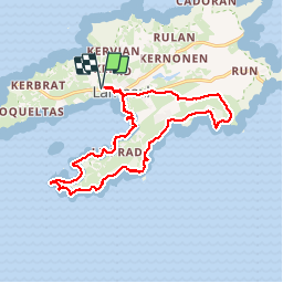

Length
15.9 km

Max alt
37 m

Uphill gradient
212 m
Km-Effort
18.7 km

Min alt
0 m

Downhill gradient
211 m
Boucle
Yes
Creation date :
2018-04-17 10:08:45.537
Updated on :
2018-04-17 10:08:45.537
8h16
Difficulty : Easy

FREE GPS app for hiking
 SityTrail
IGN / Geographical institutes
SityTrail Plus
The world is yours!
About
Trail Walking of 15.9 km to be discovered at Brittany, Finistère, Ushant. This trail is proposed by Claudele.
Positioning
Country:
France
Region :
Brittany
Department/Province :
Finistère
Municipality :
Ushant
Location:
Unknown
Start:(Dec)
Start:(UTM)
344590 ; 5369339 (30U) N.
Comments