


Colla Melosa - Col Bertrand

jlrayon
User
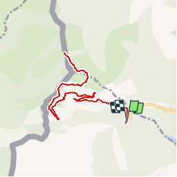

Length
11.5 km

Max alt
1993 m

Uphill gradient
750 m
Km-Effort
22 km

Min alt
1531 m

Downhill gradient
750 m
Boucle
Yes
Creation date :
2017-10-09 00:00:00.0
Updated on :
2017-10-09 00:00:00.0
4h18
Difficulty : Difficult

FREE GPS app for hiking
 SityTrail
IGN / Geographical institutes
SityTrail Plus
The world is yours!
About
Trail Walking of 11.5 km to be discovered at Liguria, Imperia, Pigna. This trail is proposed by jlrayon.
Description
Projet de randonnée de la Colla Melosa au Col Bertrand en A/R
Positioning
Country:
Italy
Region :
Liguria
Department/Province :
Imperia
Municipality :
Pigna
Location:
Unknown
Start:(Dec)
Start:(UTM)
394464 ; 4871515 (32T) N.
Comments