Haut-Fays -Proiji (HF1)
La Grande Forêt de Saint-Hubert
Randonnées de la Grande Forêt de Saint-Hubert GUIDE+
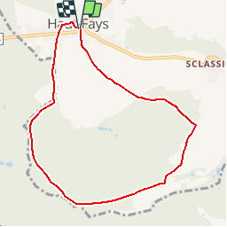

Length
7.7 km

Max alt
436 m

Uphill gradient
138 m
Km-Effort
9.5 km

Min alt
336 m

Downhill gradient
137 m
Boucle
Yes
Creation date :
2018-04-09 12:34:58.382
Updated on :
2018-04-09 12:34:58.382
1h45
Difficulty : Easy

FREE GPS app for hiking
 SityTrail
IGN / Geographical institutes
SityTrail Plus
The world is yours!
About
Trail Walking of 7.7 km to be discovered at Wallonia, Luxembourg, Daverdisse. This trail is proposed by La Grande Forêt de Saint-Hubert.
Description
HF1- PROIJI
7-8km - Parking et départ Grand-Place à Haut-Fays.
Bottes conseillées.


Positioning
Country:
Belgium
Region :
Wallonia
Department/Province :
Luxembourg
Municipality :
Daverdisse
Location:
Haut-Fays
Start:(Dec)
Start:(UTM)
644577 ; 5540709 (31U) N.
Comments