


Mallorca- Port d'es Canonge 13-10-2017

fredetpascale
User GUIDE
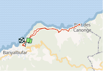

Length
8.7 km

Max alt
210 m

Uphill gradient
360 m
Km-Effort
13.4 km

Min alt
0 m

Downhill gradient
350 m
Boucle
Yes
Creation date :
2018-04-17 10:39:46.254
Updated on :
2018-04-17 10:39:46.254
2h09
Difficulty : Easy

FREE GPS app for hiking
 SityTrail
IGN / Geographical institutes
SityTrail Plus
The world is yours!
About
Trail Walking of 8.7 km to be discovered at Balearic Islands, Unknown, Banyalbufar. This trail is proposed by fredetpascale.
Positioning
Country:
Spain
Region :
Balearic Islands
Department/Province :
Unknown
Municipality :
Banyalbufar
Location:
Unknown
Start:(Dec)
Start:(UTM)
458939 ; 4393461 (31S) N.
Comments