


Arromanches

Roulland
User

Length
19.3 km

Max alt
58 m

Uphill gradient
206 m
Km-Effort
22 km

Min alt
0 m

Downhill gradient
198 m
Boucle
Yes
Creation date :
2018-04-17 10:49:27.966
Updated on :
2018-04-17 10:49:27.966
4h51
Difficulty : Easy

FREE GPS app for hiking
 SityTrail
IGN / Geographical institutes
SityTrail Plus
The world is yours!
About
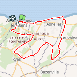
Trail Walking of 19.3 km to be discovered at Normandy, Calvados, Arromanches-les-Bains. This trail is proposed by Roulland.
Photos


Positioning
Country:
France
Region :
Normandy
Department/Province :
Calvados
Municipality :
Arromanches-les-Bains
Location:
Unknown
Start:(Dec)
Start:(UTM)
672597 ; 5467774 (30U) N.
Comments