


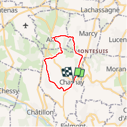
69 CHARNAY (Lozanne) Chapelle des Chanoinesses

trietsch
User

Length
9.3 km

Max alt
445 m

Uphill gradient
245 m
Km-Effort
12.6 km

Min alt
250 m

Downhill gradient
242 m
Boucle
Yes
Creation date :
2018-04-17 10:51:38.585
Updated on :
2020-01-04 20:28:52.26
2h41
Difficulty : Easy

FREE GPS app for hiking
 SityTrail
IGN / Geographical institutes
SityTrail Plus
The world is yours!
About
Trail Walking of 9.3 km to be discovered at Auvergne-Rhône-Alpes, Rhône, Charnay. This trail is proposed by trietsch.
Description
Visite chapelle des chanoinesse à Cluny
Positioning
Country:
France
Region :
Auvergne-Rhône-Alpes
Department/Province :
Rhône
Municipality :
Charnay
Location:
Unknown
Start:(Dec)
Start:(UTM)
629379 ; 5083263 (31T) N.
Comments