


l este ton

papajp
User
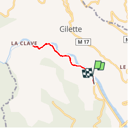

Length
4.8 km

Max alt
170 m

Uphill gradient
106 m
Km-Effort
6.2 km

Min alt
125 m

Downhill gradient
105 m
Boucle
No
Creation date :
2019-02-16 19:06:35.625
Updated on :
2019-02-16 19:06:35.636
1h07
Difficulty : Unknown

FREE GPS app for hiking
 SityTrail
IGN / Geographical institutes
SityTrail Plus
The world is yours!
About
Trail Other activity of 4.8 km to be discovered at Provence-Alpes-Côte d'Azur, Maritime Alps, Le Broc. This trail is proposed by papajp.
Positioning
Country:
France
Region :
Provence-Alpes-Côte d'Azur
Department/Province :
Maritime Alps
Municipality :
Le Broc
Location:
Unknown
Start:(Dec)
Start:(UTM)
352989 ; 4855510 (32T) N.
Comments