


Cogny (10 km D. 323 m)

Thomasdanielle
User
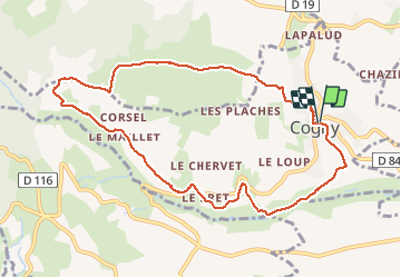

Length
9.9 km

Max alt
537 m

Uphill gradient
286 m
Km-Effort
13.8 km

Min alt
291 m

Downhill gradient
290 m
Boucle
Yes
Creation date :
2018-04-17 11:05:22.478
Updated on :
2018-04-17 11:05:22.478
2h58
Difficulty : Easy

FREE GPS app for hiking
 SityTrail
IGN / Geographical institutes
SityTrail Plus
The world is yours!
About
Trail Walking of 9.9 km to be discovered at Auvergne-Rhône-Alpes, Rhône, Cogny. This trail is proposed by Thomasdanielle.
Description
Départ parking de l'église
Positioning
Country:
France
Region :
Auvergne-Rhône-Alpes
Department/Province :
Rhône
Municipality :
Cogny
Location:
Unknown
Start:(Dec)
Start:(UTM)
625903 ; 5094040 (31T) N.
Comments