


COGNY - 69

AndreLACOMBE
User
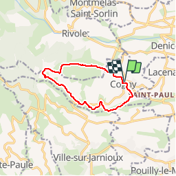

Length
10.1 km

Max alt
538 m

Uphill gradient
294 m
Km-Effort
14 km

Min alt
291 m

Downhill gradient
296 m
Boucle
Yes
Creation date :
2018-04-17 11:05:23.888
Updated on :
2018-04-17 11:05:23.888
3h09
Difficulty : Easy

FREE GPS app for hiking
 SityTrail
IGN / Geographical institutes
SityTrail Plus
The world is yours!
About
Trail Walking of 10.1 km to be discovered at Auvergne-Rhône-Alpes, Rhône, Cogny. This trail is proposed by AndreLACOMBE.
Description
Boucle au départ du parking de l'église.
Positioning
Country:
France
Region :
Auvergne-Rhône-Alpes
Department/Province :
Rhône
Municipality :
Cogny
Location:
Unknown
Start:(Dec)
Start:(UTM)
625890 ; 5094060 (31T) N.
Comments