


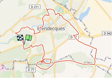
Blendecques (2) 12.7Km Dén P 137m

alain62rando
User

Length
12.6 km

Max alt
84 m

Uphill gradient
137 m
Km-Effort
14.4 km

Min alt
9 m

Downhill gradient
138 m
Boucle
Yes
Creation date :
2018-04-17 11:06:04.446
Updated on :
2019-02-08 06:53:46.513
3h13
Difficulty : Easy

FREE GPS app for hiking
 SityTrail
IGN / Geographical institutes
SityTrail Plus
The world is yours!
About
Trail Walking of 12.6 km to be discovered at Hauts-de-France, Pas-de-Calais, Blendecques. This trail is proposed by alain62rando.
Description
Départ Stand de Tir (Aux 2 Lions)
Rando avec 7.7Km de chemins
Positioning
Country:
France
Region :
Hauts-de-France
Department/Province :
Pas-de-Calais
Municipality :
Blendecques
Location:
Unknown
Start:(Dec)
Start:(UTM)
448267 ; 5617988 (31U) N.
Comments