


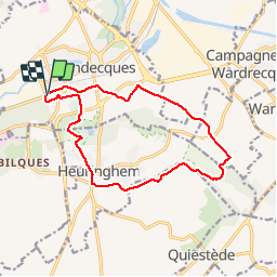
Blendecques (1) 12.8km Dén P 145m

alain62rando
User

Length
12.8 km

Max alt
82 m

Uphill gradient
145 m
Km-Effort
14.7 km

Min alt
18 m

Downhill gradient
137 m
Boucle
Yes
Creation date :
2018-04-17 11:07:36.853
Updated on :
2019-02-08 06:49:03.229
2h40
Difficulty : Easy

FREE GPS app for hiking
 SityTrail
IGN / Geographical institutes
SityTrail Plus
The world is yours!
About
Trail Walking of 12.8 km to be discovered at Hauts-de-France, Pas-de-Calais, Blendecques. This trail is proposed by alain62rando.
Description
Au départ du stand de tir de Blendecques près des 2 lions une randonnée qui vous fera traversée les landes à Heuringhem et à Blendecques.
Rando avec 6.1km de chemins
Positioning
Country:
France
Region :
Hauts-de-France
Department/Province :
Pas-de-Calais
Municipality :
Blendecques
Location:
Unknown
Start:(Dec)
Start:(UTM)
448281 ; 5617985 (31U) N.
Comments