


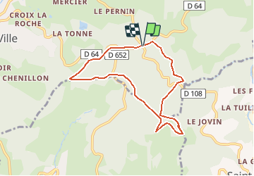
Col du Pavillon

Thomasdanielle
User

Length
7.6 km

Max alt
805 m

Uphill gradient
190 m
Km-Effort
10.2 km

Min alt
700 m

Downhill gradient
189 m
Boucle
Yes
Creation date :
2018-04-17 11:09:26.374
Updated on :
2018-04-17 11:09:26.374
2h13
Difficulty : Very easy

FREE GPS app for hiking
 SityTrail
IGN / Geographical institutes
SityTrail Plus
The world is yours!
About
Trail Walking of 7.6 km to be discovered at Auvergne-Rhône-Alpes, Rhône, Cours. This trail is proposed by Thomasdanielle.
Description
Départ/Arrivée : Col du Pavillon
Positioning
Country:
France
Region :
Auvergne-Rhône-Alpes
Department/Province :
Rhône
Municipality :
Cours
Location:
Cours-la-Ville
Start:(Dec)
Start:(UTM)
605154 ; 5105819 (31T) N.
Comments