


point leo

ARPF
User
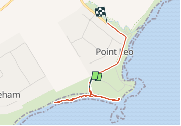

Length
3.8 km

Max alt
23 m

Uphill gradient
40 m
Km-Effort
4.3 km

Min alt
0 m

Downhill gradient
33 m
Boucle
No
Creation date :
2018-04-17 11:13:51.624
Updated on :
2018-04-17 11:13:51.624
1h39
Difficulty : Easy

FREE GPS app for hiking
 SityTrail
IGN / Geographical institutes
SityTrail Plus
The world is yours!
About
Trail Walking of 3.8 km to be discovered at Victoria, Shire of Mornington Peninsula. This trail is proposed by ARPF.
Positioning
Country:
Australia
Region :
Victoria
Department/Province :
Shire of Mornington Peninsula
Municipality :
Unknown
Location:
Unknown
Start:(Dec)
Start:(UTM)
331609 ; 5745396 (55H) S.
Comments