


23/10/2017 - De La Loisance au Douétel, Antrain/Tremblay

babeth35
User
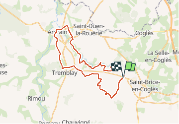

Length
31 km

Max alt
116 m

Uphill gradient
337 m
Km-Effort
35 km

Min alt
11 m

Downhill gradient
339 m
Boucle
Yes
Creation date :
2018-04-17 11:20:21.28
Updated on :
2020-07-20 15:11:11.945
7h37
Difficulty : Medium

FREE GPS app for hiking
 SityTrail
IGN / Geographical institutes
SityTrail Plus
The world is yours!
About
Trail Walking of 31 km to be discovered at Brittany, Ille-et-Vilaine, Val-Couesnon. This trail is proposed by babeth35.
Positioning
Country:
France
Region :
Brittany
Department/Province :
Ille-et-Vilaine
Municipality :
Val-Couesnon
Location:
Tremblay
Start:(Dec)
Start:(UTM)
618839 ; 5364062 (30U) N.
Comments