


IME GB - rando VTT - 23 oct 2017

norbertmarteau
User

Length
21 km

Max alt
391 m

Uphill gradient
386 m
Km-Effort
26 km

Min alt
230 m

Downhill gradient
393 m
Boucle
Yes
Creation date :
2018-04-17 11:22:03.771
Updated on :
2018-04-17 11:22:03.771
1h51
Difficulty : Medium

FREE GPS app for hiking
 SityTrail
IGN / Geographical institutes
SityTrail Plus
The world is yours!
About
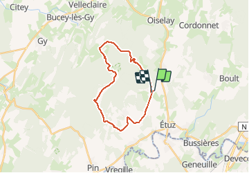
Trail Mountain bike of 21 km to be discovered at Bourgogne-Franche-Comté, Haute-Saône, Montboillon. This trail is proposed by norbertmarteau.
Positioning
Country:
France
Region :
Bourgogne-Franche-Comté
Department/Province :
Haute-Saône
Municipality :
Montboillon
Location:
Unknown
Start:(Dec)
Start:(UTM)
720884 ; 5250768 (31T) N.
Comments