


25.10.2017 - LOYZANCE et DOUETEL

babeth35
User
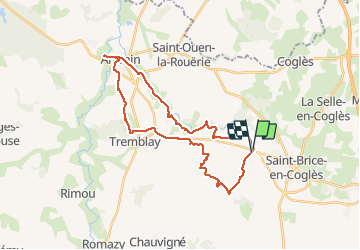

Length
31 km

Max alt
116 m

Uphill gradient
349 m
Km-Effort
36 km

Min alt
10 m

Downhill gradient
347 m
Boucle
Yes
Creation date :
2018-04-17 11:25:50.875
Updated on :
2020-07-20 15:11:02.27
7h08
Difficulty : Medium

FREE GPS app for hiking
 SityTrail
IGN / Geographical institutes
SityTrail Plus
The world is yours!
About
Trail Walking of 31 km to be discovered at Brittany, Ille-et-Vilaine, Maen-Roch. This trail is proposed by babeth35.
Positioning
Country:
France
Region :
Brittany
Department/Province :
Ille-et-Vilaine
Municipality :
Maen-Roch
Location:
Saint-Brice-en-Coglès
Start:(Dec)
Start:(UTM)
618814 ; 5364009 (30U) N.
Comments