


Pic de l'Homme

xav34830
User
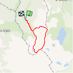

Length
10.6 km

Max alt
2466 m

Uphill gradient
1163 m
Km-Effort
26 km

Min alt
1415 m

Downhill gradient
1161 m
Boucle
Yes
Creation date :
2018-04-17 11:31:45.102
Updated on :
2018-04-17 11:31:45.102
--
Difficulty : Medium

FREE GPS app for hiking
 SityTrail
IGN / Geographical institutes
SityTrail Plus
The world is yours!
About
Trail Walking of 10.6 km to be discovered at Occitania, Ariège, Orgeix. This trail is proposed by xav34830.


Positioning
Country:
France
Region :
Occitania
Department/Province :
Ariège
Municipality :
Orgeix
Location:
Unknown
Start:(Dec)
Start:(UTM)
407565 ; 4724582 (31T) N.
Comments