


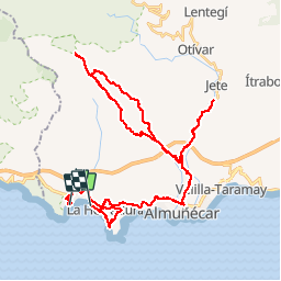
au dessus de Almunecar. 30 oct 2017

jpipacific
User

Length
63 km

Max alt
760 m

Uphill gradient
1836 m
Km-Effort
88 km

Min alt
1 m

Downhill gradient
1911 m
Boucle
No
Creation date :
2018-04-17 11:47:10.709
Updated on :
2019-09-09 12:40:03.832
1h50
Difficulty : Easy

FREE GPS app for hiking
 SityTrail
IGN / Geographical institutes
SityTrail Plus
The world is yours!
About
Trail Moto cross of 63 km to be discovered at Andalusia, Granada, Almuñécar. This trail is proposed by jpipacific.
Description
Route de début de randonnée difficile sur route très étroite avec une circulation venant en face dangereuse. Cette route du début doit être évitée.
Positioning
Country:
Spain
Region :
Andalusia
Department/Province :
Granada
Municipality :
Almuñécar
Location:
Unknown
Start:(Dec)
Start:(UTM)
432140 ; 4066018 (30S) N.
Comments