


Chasselay

Thomasdanielle
User
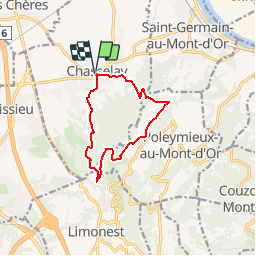

Length
10 km

Max alt
539 m

Uphill gradient
337 m
Km-Effort
14.5 km

Min alt
235 m

Downhill gradient
337 m
Boucle
Yes
Creation date :
2018-04-17 11:51:20.791
Updated on :
2018-04-17 11:51:20.791
3h07
Difficulty : Easy

FREE GPS app for hiking
 SityTrail
IGN / Geographical institutes
SityTrail Plus
The world is yours!
About
Trail Walking of 10 km to be discovered at Auvergne-Rhône-Alpes, Rhône, Chasselay. This trail is proposed by Thomasdanielle.
Positioning
Country:
France
Region :
Auvergne-Rhône-Alpes
Department/Province :
Rhône
Municipality :
Chasselay
Location:
Unknown
Start:(Dec)
Start:(UTM)
637432 ; 5081509 (31T) N.
Comments