Trail Walking Nuret-le-Ferron - De vallons en brandes  - Photo
 Phil36
Phil36

User

© OpenStreetMap contributors
Length
Length
13 km
Max alt
Max alt
166 m
Uphill gradient
Uphill gradient
107 m
Km-Effort
Km-Effort  
14.4 km
Min alt
Min alt
129 m
Downhill gradient
Downhill gradient
106 m
Boucle
Boucle
Yes
Creation date :
2018-04-17 11:54:31.467
Updated on :
2018-04-17 11:54:31.467

(0 Reviews)

Walking
Walking
2h46
Difficulty : Medium

Scan this QR Code to open this trail in the SityTrail application

FREE GPS app for hiking

Logo SityTrail SityTrail

IGN / Geographical institutes

Download SityTrail from the App Store Download SityTrail from Google Play

Logo SityTrail SityTrail World

The world is yours!

Download SityTrail from the App Store Download SityTrail from Google Play Download SityTrail on Huawei AppGallery

About

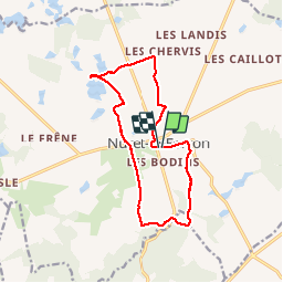
Trail Walking of 13 km to be discovered at Centre-Loire Valley, Indre, Nuret-le-Ferron. This trail is proposed by Phil36.

Description

Départ Nuret-le-Ferron(Balissage jaune) Une ballade agréable .

Elevation profile

Positioning

Country:
France
Region :
Centre-Loire Valley
Department/Province :
Indre
Municipality :
Nuret-le-Ferron
Location:
Unknown
Start:(UTM)
380405 ; 5171165 (31T) N.

Trails nearby

Trail Running Chasseneuil - PR9 Chasseneuil - Photo
Running
pivol

Running

Easy
(1)
Chasseneuil, Centre-Loire Valley, Indre, France
8 km | 9.3 km-effort
1min
Yes


Close
My subscriptions