


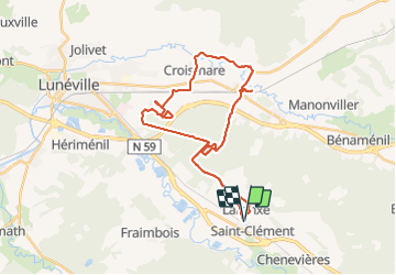
sortie vtt du 01112017

fabwin
User GUIDE

Length
33 km

Max alt
264 m

Uphill gradient
202 m
Km-Effort
36 km

Min alt
224 m

Downhill gradient
202 m
Boucle
Yes
Creation date :
2018-04-17 11:54:32.602
Updated on :
2018-04-17 11:54:32.602
2h23
Difficulty : Easy

FREE GPS app for hiking
 SityTrail
IGN / Geographical institutes
SityTrail Plus
The world is yours!
About
Trail Mountain bike of 33 km to be discovered at Grand Est, Meurthe-et-Moselle, Saint-Clément. This trail is proposed by fabwin.
Description
Sortie Sous le soleil avec Ange.
Photos


Positioning
Country:
France
Region :
Grand Est
Department/Province :
Meurthe-et-Moselle
Municipality :
Saint-Clément
Location:
Unknown
Start:(Dec)
Start:(UTM)
323020 ; 5378531 (32U) N.
Comments