


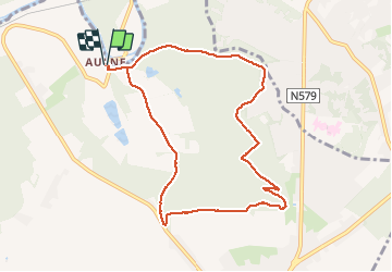
Abbaye d Aulne 2-11-17

andremusin
User

Length
8.3 km

Max alt
214 m

Uphill gradient
149 m
Km-Effort
10.3 km

Min alt
111 m

Downhill gradient
149 m
Boucle
Yes
Creation date :
2018-04-17 12:02:07.813
Updated on :
2018-04-17 12:02:07.813
1h53
Difficulty : Unknown

FREE GPS app for hiking
 SityTrail
IGN / Geographical institutes
SityTrail Plus
The world is yours!
About
Trail Nordic walking of 8.3 km to be discovered at Wallonia, Hainaut, Thuin. This trail is proposed by andremusin.
Positioning
Country:
Belgium
Region :
Wallonia
Department/Province :
Hainaut
Municipality :
Thuin
Location:
Gozée
Start:(Dec)
Start:(UTM)
594792 ; 5580213 (31U) N.
Comments