


LES ESTABLES - 43 - Le Mont Mézenc de A à Z.

AndreLACOMBE
User
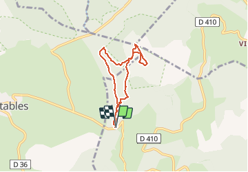

Length
5.9 km

Max alt
1740 m

Uphill gradient
246 m
Km-Effort
9.2 km

Min alt
1511 m

Downhill gradient
247 m
Boucle
Yes
Creation date :
2018-04-17 12:06:01.716
Updated on :
2018-04-17 12:06:01.716
3h03
Difficulty : Easy

FREE GPS app for hiking
 SityTrail
IGN / Geographical institutes
SityTrail Plus
The world is yours!
About
Trail Walking of 5.9 km to be discovered at Auvergne-Rhône-Alpes, Ardèche, Borée. This trail is proposed by AndreLACOMBE.
Description
Boucle au départ du col de la Croix de Boutières - Alt. 1506 m.
Positioning
Country:
France
Region :
Auvergne-Rhône-Alpes
Department/Province :
Ardèche
Municipality :
Borée
Location:
Unknown
Start:(Dec)
Start:(UTM)
593561 ; 4972471 (31T) N.
Comments