


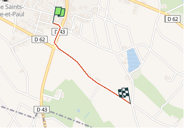
Odenas (9,7 km-D. 302 m)

Thomasdanielle
User

Length
809 m

Max alt
304 m

Uphill gradient
0 m
Km-Effort
899 m

Min alt
276 m

Downhill gradient
27 m
Boucle
No
Creation date :
2018-04-17 12:06:03.027
Updated on :
2018-04-17 12:06:03.027
5m
Difficulty : Easy

FREE GPS app for hiking
 SityTrail
IGN / Geographical institutes
SityTrail Plus
The world is yours!
About
Trail Walking of 809 m to be discovered at Auvergne-Rhône-Alpes, Rhône, Odenas. This trail is proposed by Thomasdanielle.
Description
A/R parking centre du village
Positioning
Country:
France
Region :
Auvergne-Rhône-Alpes
Department/Province :
Rhône
Municipality :
Odenas
Location:
Unknown
Start:(Dec)
Start:(UTM)
627219 ; 5105027 (31T) N.
Comments