


rando 3 nov avec Thierry

jpipacific
User
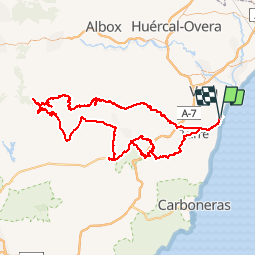

Length
212 km

Max alt
1463 m

Uphill gradient
5013 m
Km-Effort
279 km

Min alt
1 m

Downhill gradient
5019 m
Boucle
Yes
Creation date :
2018-04-17 12:06:21.066
Updated on :
2019-09-09 12:33:27.758
6h10
Difficulty : Difficult

FREE GPS app for hiking
 SityTrail
IGN / Geographical institutes
SityTrail Plus
The world is yours!
About
Trail Moto cross of 212 km to be discovered at Andalusia, Almeria, Garrucha. This trail is proposed by jpipacific.
Description
vers Calar Alto
Positioning
Country:
Spain
Region :
Andalusia
Department/Province :
Almeria
Municipality :
Garrucha
Location:
Unknown
Start:(Dec)
Start:(UTM)
604486 ; 4116195 (30S) N.
Comments