


Via Julia Augusta

jlrayon
User
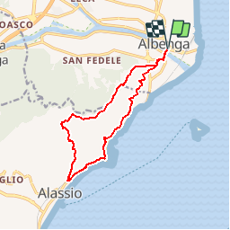

Length
13.4 km

Max alt
504 m

Uphill gradient
746 m
Km-Effort
23 km

Min alt
4 m

Downhill gradient
746 m
Boucle
Yes
Creation date :
2017-12-02 08:18:56.922
Updated on :
2017-12-02 08:18:56.922
4h36
Difficulty : Medium

FREE GPS app for hiking
 SityTrail
IGN / Geographical institutes
SityTrail Plus
The world is yours!
About
Trail Walking of 13.4 km to be discovered at Liguria, Savona, Albenga. This trail is proposed by jlrayon.
Description
Projet:
D'Albenga à Alassio, aller par le Monte Bigone Retour par la l'ancienne voie romaine
Positioning
Country:
Italy
Region :
Liguria
Department/Province :
Savona
Municipality :
Albenga
Location:
Unknown
Start:(Dec)
Start:(UTM)
437076 ; 4877486 (32T) N.
Comments