


Garrucha La Herradura

jpipacific
User
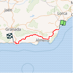

Length
266 km

Max alt
1360 m

Uphill gradient
5877 m
Km-Effort
344 km

Min alt
5 m

Downhill gradient
5818 m
Boucle
No
Creation date :
2018-04-17 12:10:38.394
Updated on :
2019-09-09 12:31:42.533
4h00
Difficulty : Very easy

FREE GPS app for hiking
 SityTrail
IGN / Geographical institutes
SityTrail Plus
The world is yours!
About
Trail Moto cross of 266 km to be discovered at Andalusia, Almeria, Garrucha. This trail is proposed by jpipacific.
Positioning
Country:
Spain
Region :
Andalusia
Department/Province :
Almeria
Municipality :
Garrucha
Location:
Unknown
Start:(Dec)
Start:(UTM)
604290 ; 4115731 (30S) N.
Comments