


Trail Kluisberg (elevation: 650m)

rutgerverschaeve
User
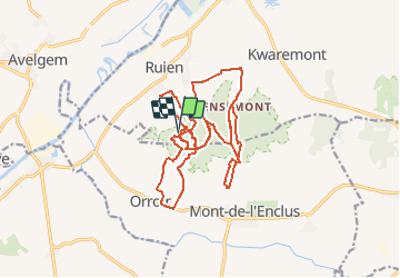

Length
20 km

Max alt
154 m

Uphill gradient
668 m
Km-Effort
29 km

Min alt
19 m

Downhill gradient
664 m
Boucle
Yes
Creation date :
2018-04-17 12:12:29.557
Updated on :
2018-04-17 12:12:29.557
2h00
Difficulty : Medium

FREE GPS app for hiking
 SityTrail
IGN / Geographical institutes
SityTrail Plus
The world is yours!
About
Trail Running of 20 km to be discovered at Flanders, East Flanders, Kluisbergen. This trail is proposed by rutgerverschaeve.
Description
Trail Mont de l'Éclus
Positioning
Country:
Belgium
Region :
Flanders
Department/Province :
East Flanders
Municipality :
Kluisbergen
Location:
Ruien
Start:(Dec)
Start:(UTM)
534618 ; 5623364 (31U) N.
Comments