


Retour avec Thierry

jpipacific
User

Length
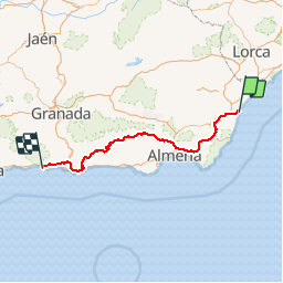
298 km

Max alt
1357 m

Uphill gradient
8339 m
Km-Effort
409 km

Min alt
1 m

Downhill gradient
8273 m
Boucle
No
Creation date :
2018-04-17 12:13:17.492
Updated on :
2019-09-09 12:29:49.274
5h18
Difficulty : Very easy

FREE GPS app for hiking
 SityTrail
IGN / Geographical institutes
SityTrail Plus
The world is yours!
About
Trail Moto cross of 298 km to be discovered at Andalusia, Almeria, Garrucha. This trail is proposed by jpipacific.
Description
Garrucha. La Herradura
Positioning
Country:
Spain
Region :
Andalusia
Department/Province :
Almeria
Municipality :
Garrucha
Location:
Unknown
Start:(Dec)
Start:(UTM)
604501 ; 4116196 (30S) N.
Comments