


Beyne-Heusay le 04102017

jojolemarcheur
User
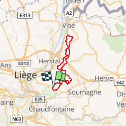

Length
42 km

Max alt
250 m

Uphill gradient
657 m
Km-Effort
50 km

Min alt
78 m

Downhill gradient
656 m
Boucle
Yes
Creation date :
2018-04-17 12:14:14.499
Updated on :
2018-04-17 12:14:14.499
7h33
Difficulty : Unknown

FREE GPS app for hiking
 SityTrail
IGN / Geographical institutes
SityTrail Plus
The world is yours!
About
Trail Other activity of 42 km to be discovered at Wallonia, Liège, Beyne-Heusay. This trail is proposed by jojolemarcheur.
Positioning
Country:
Belgium
Region :
Wallonia
Department/Province :
Liège
Municipality :
Beyne-Heusay
Location:
Beyne-Heusay
Start:(Dec)
Start:(UTM)
687767 ; 5611306 (31U) N.
Comments