


6. Brousse le Chateau

Jaceu
User
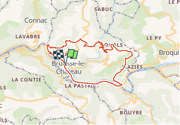

Length
18.2 km

Max alt
515 m

Uphill gradient
676 m
Km-Effort
27 km

Min alt
230 m

Downhill gradient
671 m
Boucle
Yes
Creation date :
2018-04-17 12:16:16.934
Updated on :
2018-04-17 12:16:16.934
5h45
Difficulty : Medium

FREE GPS app for hiking
 SityTrail
IGN / Geographical institutes
SityTrail Plus
The world is yours!
About
Trail Walking of 18.2 km to be discovered at Occitania, Aveyron, Brousse-le-Château. This trail is proposed by Jaceu.
Positioning
Country:
France
Region :
Occitania
Department/Province :
Aveyron
Municipality :
Brousse-le-Château
Location:
Unknown
Start:(Dec)
Start:(UTM)
469741 ; 4871695 (31T) N.
Comments