


4. Le Combalou et Roquefort

Jaceu
User
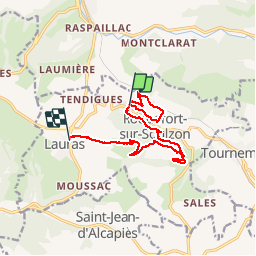

Length
12.7 km

Max alt
791 m

Uphill gradient
452 m
Km-Effort
19 km

Min alt
439 m

Downhill gradient
523 m
Boucle
No
Creation date :
2018-04-17 12:16:18.362
Updated on :
2018-04-17 12:16:18.362
4h04
Difficulty : Medium

FREE GPS app for hiking
 SityTrail
IGN / Geographical institutes
SityTrail Plus
The world is yours!
About
Trail Walking of 12.7 km to be discovered at Occitania, Aveyron, Roquefort-sur-Soulzon. This trail is proposed by Jaceu.
Positioning
Country:
France
Region :
Occitania
Department/Province :
Aveyron
Municipality :
Roquefort-sur-Soulzon
Location:
Unknown
Start:(Dec)
Start:(UTM)
498528 ; 4869793 (31T) N.
Comments