


Balazuc

pierre.chau
User
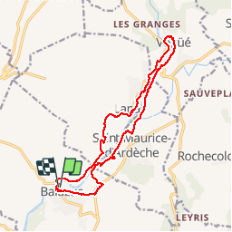

Length
17 km

Max alt
233 m

Uphill gradient
340 m
Km-Effort
21 km

Min alt
129 m

Downhill gradient
341 m
Boucle
Yes
Creation date :
2018-04-17 12:16:20.203
Updated on :
2018-04-17 12:16:20.203
5h56
Difficulty : Unknown

FREE GPS app for hiking
 SityTrail
IGN / Geographical institutes
SityTrail Plus
The world is yours!
About
Trail Walking of 17 km to be discovered at Auvergne-Rhône-Alpes, Ardèche, Balazuc. This trail is proposed by pierre.chau.
Description
Facile avec traversées de beaux village
Positioning
Country:
France
Region :
Auvergne-Rhône-Alpes
Department/Province :
Ardèche
Municipality :
Balazuc
Location:
Unknown
Start:(Dec)
Start:(UTM)
609102 ; 4929490 (31T) N.
Comments