


coulimmiers_pm

FOUCHET
User
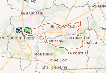

Length
14.7 km

Max alt
142 m

Uphill gradient
218 m
Km-Effort
17.6 km

Min alt
69 m

Downhill gradient
215 m
Boucle
Yes
Creation date :
2018-04-17 12:28:14.949
Updated on :
2018-04-17 12:28:14.949
--
Difficulty : Unknown

FREE GPS app for hiking
 SityTrail
IGN / Geographical institutes
SityTrail Plus
The world is yours!
About
Trail Walking of 14.7 km to be discovered at Ile-de-France, Seine-et-Marne, Coulommiers. This trail is proposed by FOUCHET.
Positioning
Country:
France
Region :
Ile-de-France
Department/Province :
Seine-et-Marne
Municipality :
Coulommiers
Location:
Unknown
Start:(Dec)
Start:(UTM)
506490 ; 5406670 (31U) N.
Comments