


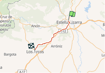
Compostelle 39 - Estella -> Los Arcos

uru2010
User

Length
24 km

Max alt
675 m

Uphill gradient
455 m
Km-Effort
30 km

Min alt
419 m

Downhill gradient
436 m
Boucle
No
Creation date :
2018-04-17 12:29:45.52
Updated on :
2018-04-17 12:29:45.52
5h48
Difficulty : Easy

FREE GPS app for hiking
 SityTrail
IGN / Geographical institutes
SityTrail Plus
The world is yours!
About
Trail Walking of 24 km to be discovered at Navarre, Unknown, Estella-Lizarra. This trail is proposed by uru2010.
Description
Chemin de Saint-Jacques de Compostelle
Estella -> Los Arcos
Positioning
Country:
Spain
Region :
Navarre
Department/Province :
Unknown
Municipality :
Estella-Lizarra
Location:
Unknown
Start:(Dec)
Start:(UTM)
579032 ; 4725368 (30T) N.
Comments