


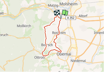
67 Dorlisheim Otrott

LUTZMarc
User

Length
23 km

Max alt
320 m

Uphill gradient
454 m
Km-Effort
29 km

Min alt
184 m

Downhill gradient
454 m
Boucle
Yes
Creation date :
2018-04-17 12:32:23.605
Updated on :
2018-04-17 12:32:23.605
4h47
Difficulty : Easy

FREE GPS app for hiking
 SityTrail
IGN / Geographical institutes
SityTrail Plus
The world is yours!
About
Trail Walking of 23 km to be discovered at Grand Est, Bas-Rhin, Dorlisheim. This trail is proposed by LUTZMarc.
Description
A travers le vignoble et sous bois
Photos

Positioning
Country:
France
Region :
Grand Est
Department/Province :
Bas-Rhin
Municipality :
Dorlisheim
Location:
Unknown
Start:(Dec)
Start:(UTM)
387380 ; 5374967 (32U) N.
Comments