


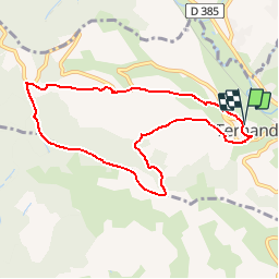
69 TERNAND

trietsch
User

Length
8.4 km

Max alt
663 m

Uphill gradient
400 m
Km-Effort
13.7 km

Min alt
300 m

Downhill gradient
398 m
Boucle
Yes
Creation date :
2018-04-17 12:39:47.298
Updated on :
2020-01-04 20:28:50.356
2h50
Difficulty : Medium

FREE GPS app for hiking
 SityTrail
IGN / Geographical institutes
SityTrail Plus
The world is yours!
About
Trail Walking of 8.4 km to be discovered at Auvergne-Rhône-Alpes, Rhône, Ternand. This trail is proposed by trietsch.
Positioning
Country:
France
Region :
Auvergne-Rhône-Alpes
Department/Province :
Rhône
Municipality :
Ternand
Location:
Unknown
Start:(Dec)
Start:(UTM)
618470 ; 5089054 (31T) N.
Comments