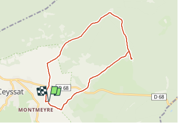
Trail Walking Ceyssat - Ceyssat_Montmeyre - Photo
 jagarnier
jagarnier

User GUIDE

© OpenStreetMap contributors
Length
Length
8.2 km
Max alt
Max alt
965 m
Uphill gradient
Uphill gradient
142 m
Km-Effort
Km-Effort  
10.1 km
Min alt
Min alt
853 m
Downhill gradient
Downhill gradient
145 m
Boucle
Boucle
Yes
Creation date :
2018-04-17 12:47:06.94
Updated on :
2025-07-05 13:42:54.427

(1 Reviews)

Walking
Walking
2h30
Difficulty : Easy

Scan this QR Code to open this trail in the SityTrail application

FREE GPS app for hiking

Logo SityTrail SityTrail

IGN / Geographical institutes

Download SityTrail from the App Store Download SityTrail from Google Play

Logo SityTrail SityTrail Plus

The world is yours!

Download SityTrail from the App Store Download SityTrail from Google Play Download SityTrail on Huawei AppGallery

About

Trail Walking of 8.2 km to be discovered at Auvergne-Rhône-Alpes, Puy-de-Dôme, Ceyssat. This trail is proposed by jagarnier.

Description

Ce circuit au cœur des volcans vous amènera sur un haut lieu de la résistance auvergnate. En 1940, Montmeyre fût le premier maquis de la région. En 1943, la Gestapo attaque le camp, trois hommes sont tués, d’autres déportés, deux meurent en déportation.

Elevation profile

Photos

Positioning

Country:
France
Region :
Auvergne-Rhône-Alpes
Department/Province :
Puy-de-Dôme
Municipality :
Ceyssat
Location:
Unknown
Start:(UTM)
492919 ; 5067610 (31T) N.

Comments

Please log in to post a review or rate the element


Close
My subscriptions