


authion15

barney06
User
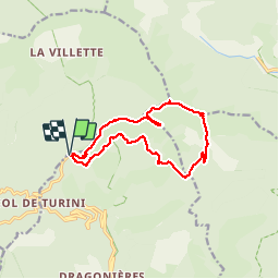

Length
13.5 km

Max alt
2068 m

Uphill gradient
467 m
Km-Effort
19.7 km

Min alt
1690 m

Downhill gradient
466 m
Boucle
Yes
Creation date :
2018-04-17 12:53:30.277
Updated on :
2018-04-17 12:53:30.277
7h14
Difficulty : Easy

FREE GPS app for hiking
 SityTrail
IGN / Geographical institutes
SityTrail Plus
The world is yours!
About
Trail Walking of 13.5 km to be discovered at Provence-Alpes-Côte d'Azur, Maritime Alps, Moulinet. This trail is proposed by barney06.
Description
marche
Positioning
Country:
France
Region :
Provence-Alpes-Côte d'Azur
Department/Province :
Maritime Alps
Municipality :
Moulinet
Location:
Unknown
Start:(Dec)
Start:(UTM)
371801 ; 4871884 (32T) N.
Comments