


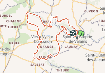
28.11.2015.Le Couesnon et la Minette.V...

chasle
User

Length
23 km

Max alt
107 m

Uphill gradient
309 m
Km-Effort
27 km

Min alt
25 m

Downhill gradient
309 m
Boucle
Yes
Creation date :
2018-04-17 12:53:51.245
Updated on :
2018-04-17 12:53:51.245
5h47
Difficulty : Medium

FREE GPS app for hiking
 SityTrail
IGN / Geographical institutes
SityTrail Plus
The world is yours!
About
Trail Walking of 23 km to be discovered at Brittany, Ille-et-Vilaine, Saint-Christophe-de-Valains. This trail is proposed by chasle.
Positioning
Country:
France
Region :
Brittany
Department/Province :
Ille-et-Vilaine
Municipality :
Saint-Christophe-de-Valains
Location:
Unknown
Start:(Dec)
Start:(UTM)
615003 ; 5355474 (30U) N.
Comments