Charnay (9,5 km-D.321 m)

Thomasdanielle
User
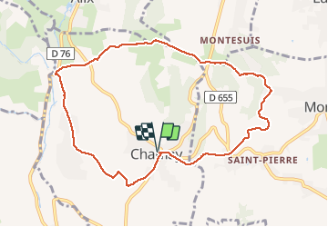

Length
9.5 km

Max alt
414 m

Uphill gradient
317 m
Km-Effort
13.7 km

Min alt
252 m

Downhill gradient
318 m
Boucle
Yes
Creation date :
2018-04-17 12:56:30.791
Updated on :
2018-04-17 12:56:30.791
2h53
Difficulty : Easy

FREE GPS app for hiking
 SityTrail
IGN / Geographical institutes
SityTrail Plus
The world is yours!
About
Trail Walking of 9.5 km to be discovered at Auvergne-Rhône-Alpes, Rhône, Charnay. This trail is proposed by Thomasdanielle.
Positioning
Country:
France
Region :
Auvergne-Rhône-Alpes
Department/Province :
Rhône
Municipality :
Charnay
Location:
Unknown
Start:(Dec)
Start:(UTM)
629362 ; 5083365 (31T) N.
Comments