


le canal d'orléans vers Grignon

BrassensJC
User

Length
11.6 km

Max alt
127 m

Uphill gradient
74 m
Km-Effort
12.5 km

Min alt
100 m

Downhill gradient
73 m
Boucle
Yes
Creation date :
2018-04-17 12:57:06.205
Updated on :
2018-04-17 12:57:06.205
2h47
Difficulty : Medium

FREE GPS app for hiking
 SityTrail
IGN / Geographical institutes
SityTrail Plus
The world is yours!
About
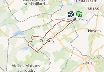
Trail Walking of 11.6 km to be discovered at Centre-Loire Valley, Loiret, Chailly-en-Gâtinais. This trail is proposed by BrassensJC.
Description
de l'écluse de la Vallée à l'écluse du bas Grignon, vers Orléans.
retour par l'écluse du point de partage, à dte vers les Quineaux, le gué des Bordes.
Positioning
Country:
France
Region :
Centre-Loire Valley
Department/Province :
Loiret
Municipality :
Chailly-en-Gâtinais
Location:
Unknown
Start:(Dec)
Start:(UTM)
462720 ; 5307878 (31T) N.
Comments