


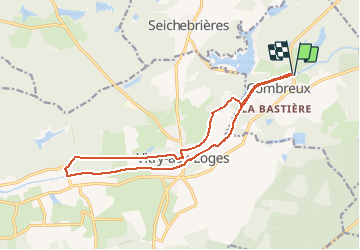
le canal d'Orléans de Combreux à Vitry

BrassensJC
User

Length
14.8 km

Max alt
129 m

Uphill gradient
100 m
Km-Effort
16.2 km

Min alt
111 m

Downhill gradient
101 m
Boucle
Yes
Creation date :
2018-04-17 12:57:14.917
Updated on :
2018-04-17 12:57:14.917
3h33
Difficulty : Medium

FREE GPS app for hiking
 SityTrail
IGN / Geographical institutes
SityTrail Plus
The world is yours!
About
Trail Walking of 14.8 km to be discovered at Centre-Loire Valley, Loiret, Combreux. This trail is proposed by BrassensJC.
Description
Combreux, Vitry aux Loges jusqu'à l'écluse de la Chênetière et retour.
Positioning
Country:
France
Region :
Centre-Loire Valley
Department/Province :
Loiret
Municipality :
Combreux
Location:
Unknown
Start:(Dec)
Start:(UTM)
448106 ; 5311816 (31T) N.
Comments