


VILLENEUVE ST GEORGES --> BOISY 12 KM

gemau77
User
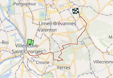

Length
10.1 km

Max alt
122 m

Uphill gradient
127 m
Km-Effort
11.7 km

Min alt
36 m

Downhill gradient
108 m
Boucle
No
Creation date :
2019-03-18 15:03:16.455
Updated on :
2020-08-25 09:18:38.951
2h32
Difficulty : Unknown

FREE GPS app for hiking
 SityTrail
IGN / Geographical institutes
SityTrail Plus
The world is yours!
About
Trail Walking of 10.1 km to be discovered at Ile-de-France, Val-de-Marne, Villeneuve-Saint-Georges. This trail is proposed by gemau77.
Description
De la Seine à Boissy
Positioning
Country:
France
Region :
Ile-de-France
Department/Province :
Val-de-Marne
Municipality :
Villeneuve-Saint-Georges
Location:
Unknown
Start:(Dec)
Start:(UTM)
459329 ; 5397614 (31U) N.
Comments