


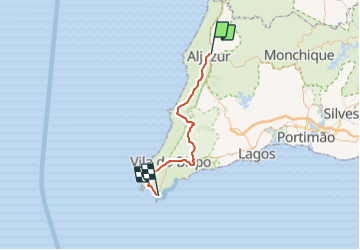
Etape 4 ALJEZUR SAGRES

paul49
User

Length
56 km

Max alt
161 m

Uphill gradient
773 m
Km-Effort
66 km

Min alt
2 m

Downhill gradient
757 m
Boucle
No
Creation date :
2018-04-17 13:05:10.026
Updated on :
2018-04-17 13:05:10.026
4h00
Difficulty : Unknown

FREE GPS app for hiking
 SityTrail
IGN / Geographical institutes
SityTrail Plus
The world is yours!
About
Trail Cycle of 56 km to be discovered at Algarve, Faro, Aljezur. This trail is proposed by paul49.
Description
Lisbonne Séville
Positioning
Country:
Portugal
Region :
Algarve
Department/Province :
Faro
Municipality :
Aljezur
Location:
Unknown
Start:(Dec)
Start:(UTM)
517840 ; 4130151 (29S) N.
Comments