


Pont Erembourg . Pont d'Ouilly

Roulland
User
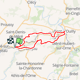

Length
24 km

Max alt
226 m

Uphill gradient
633 m
Km-Effort
33 km

Min alt
47 m

Downhill gradient
635 m
Boucle
Yes
Creation date :
2018-04-17 13:18:23.297
Updated on :
2018-04-17 13:18:23.297
5h31
Difficulty : Difficult

FREE GPS app for hiking
 SityTrail
IGN / Geographical institutes
SityTrail Plus
The world is yours!
About
Trail Walking of 24 km to be discovered at Normandy, Calvados, Saint-Denis-de-Méré. This trail is proposed by Roulland.
Positioning
Country:
France
Region :
Normandy
Department/Province :
Calvados
Municipality :
Saint-Denis-de-Méré
Location:
Unknown
Start:(Dec)
Start:(UTM)
681974 ; 5413740 (30U) N.
Comments