


tout de la lochere

margotte
User
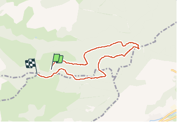

Length
7 km

Max alt
1048 m

Uphill gradient
215 m
Km-Effort
9.9 km

Min alt
870 m

Downhill gradient
217 m
Boucle
No
Creation date :
2019-06-11 14:15:57.827
Updated on :
2020-04-26 15:29:13.936
1h32
Difficulty : Unknown

FREE GPS app for hiking
 SityTrail
IGN / Geographical institutes
SityTrail Plus
The world is yours!
About
Trail Other activity of 7 km to be discovered at Grand Est, Vosges, Le Ménil. This trail is proposed by margotte.
Positioning
Country:
France
Region :
Grand Est
Department/Province :
Vosges
Municipality :
Le Ménil
Location:
Unknown
Start:(Dec)
Start:(UTM)
337288 ; 5307559 (32T) N.
Comments
parfait pour la marche nordique