Lac Fourchu via lac canard

lviallet
User
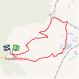

Length
8.6 km

Max alt
2064 m

Uphill gradient
435 m
Km-Effort
14.4 km

Min alt
1639 m

Downhill gradient
433 m
Boucle
Yes
Creation date :
2018-04-17 13:35:44.268
Updated on :
2018-04-17 13:35:44.268
3h02
Difficulty : Unknown

FREE GPS app for hiking
 SityTrail
IGN / Geographical institutes
SityTrail Plus
The world is yours!
About
Trail Walking of 8.6 km to be discovered at Auvergne-Rhône-Alpes, Isère, Livet-et-Gavet. This trail is proposed by lviallet.
Positioning
Country:
France
Region :
Auvergne-Rhône-Alpes
Department/Province :
Isère
Municipality :
Livet-et-Gavet
Location:
Unknown
Start:(Dec)
Start:(UTM)
728258 ; 4992941 (31T) N.
Comments