Trail Walking Marseille - de saint Marcel à la Barasse  - Photo
© OpenStreetMap contributors
Length
Length
11.5 km
Max alt
Max alt
366 m
Uphill gradient
Uphill gradient
349 m
Km-Effort
Km-Effort  
16.3 km
Min alt
Min alt
47 m
Downhill gradient
Downhill gradient
381 m
Boucle
Boucle
No
Creation date :
2018-04-17 13:43:52.542
Updated on :
2018-04-17 13:43:52.542

(0 Reviews)

Walking
Walking
3h01
Difficulty : Easy

Scan this QR Code to open this trail in the SityTrail application

FREE GPS app for hiking

Logo SityTrail SityTrail

IGN / Geographical institutes

Download SityTrail from the App Store Download SityTrail from Google Play

Logo SityTrail SityTrail World

The world is yours!

Download SityTrail from the App Store Download SityTrail from Google Play Download SityTrail on Huawei AppGallery

About

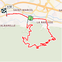
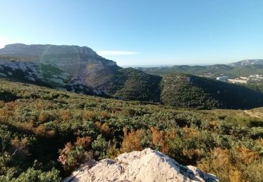
Trail Walking of 11.5 km to be discovered at Provence-Alpes-Côte d'Azur, Bouches-du-Rhône, Marseille. This trail is proposed by aligataure.

Description

1ere randonnée et merci l'appli

Elevation profile

Photos

Points of interest

Point of interest Marseille - Point 3 - Photo
aligataure
MARSEILLE 
Point of interest Marseille - Point 4 - Photo
aligataure
MARSEILLE 
Point of interest Marseille - Point 5 - Photo
aligataure
MARSEILLE 
Point of interest Marseille - Point 8 - Photo
aligataure
MARSEILLE 
Point of interest Marseille - Point 9 - Photo
aligataure
MARSEILLE 
Point of interest Marseille - Point 11 - Photo
aligataure
MARSEILLE 
Point of interest Marseille - Point 12 - Photo
aligataure
MARSEILLE 
Point of interest Marseille - Point 14 - Photo
aligataure
MARSEILLE 
Point of interest Marseille - Point 17 - Photo
aligataure
MARSEILLE 
Point of interest Marseille - Point 18 - Photo
aligataure
MARSEILLE 

Positioning

Country:
France
Region :
Provence-Alpes-Côte d'Azur
Department/Province :
Bouches-du-Rhône
Municipality :
Marseille
Location:
11th Arrondissement
Start:(UTM)
700116 ; 4795285 (31T) N.

Trails nearby

Trail Walking Marseille - Luminy: Le chemin du Centaure - Photo
Walking
GUIDE
lhomme.ph

Walking

Easy
(1)
Marseille, Provence-Alpes-Côte d'Azur, Bouches-du-Rhône, France
8.6 km | 12.5 km-effort
2h 12min
Yes
Trail On foot Marseille - FR-6 - Photo
On foot
PRO

On foot

Medium
Marseille, Provence-Alpes-Côte d'Azur, Bouches-du-Rhône, France
12.8 km | 23 km-effort
5h 13min
No
Trail Walking Marseille - HBR 2023 Mt Carpiagne, depuis La Barasse à Marseille - Photo
Walking
jmheydorff

Walking

Difficult
(4)
Marseille, Provence-Alpes-Côte d'Azur, Bouches-du-Rhône, France
12.6 km | 22 km-effort
5h 38min
Yes
Trail Other activity Marseille - Garlaban - Photo
Other activity
JosephRigolet

Other activity

Very easy
(1)
Marseille, Provence-Alpes-Côte d'Azur, Bouches-du-Rhône, France
15.8 km | 25 km-effort
6h 35min
Yes
Trail Walking Marseille - HBR 2124 Mt Carpiagne, depuis La Barasse à Marseille - Photo
Walking
Baltykatt

Walking

Difficult
(1)
Marseille, Provence-Alpes-Côte d'Azur, Bouches-du-Rhône, France
16.4 km | 28 km-effort
5h 38min
Yes
Trail Walking Marseille - HBR 2124 Mt Carpiagne, depuis La Barasse à Marseille - Photo
Walking
jmheydorff

Walking

Difficult
(4)
Marseille, Provence-Alpes-Côte d'Azur, Bouches-du-Rhône, France
16.4 km | 28 km-effort
5h 38min
Yes
Trail Walking Marseille - Vallon Ricard - Pied des Falaises de Luminy - Photo
Walking
GUIDE
lhomme.ph

Walking

Easy
Marseille, Provence-Alpes-Côte d'Azur, Bouches-du-Rhône, France
8.2 km | 11.3 km-effort
1h 44min
Yes
Trail Walking Marseille - Carla an - Photo
Walking
GUIDE
Roger Philippe Wallez

Walking

Very difficult
Marseille, Provence-Alpes-Côte d'Azur, Bouches-du-Rhône, France
20 km | 31 km-effort
5h 54min
No
Trail Walking Marseille - Calanques, cirque des Pételins-08-11-2023 - Photo
Walking
Christiancordin

Walking

Difficult
Marseille, Provence-Alpes-Côte d'Azur, Bouches-du-Rhône, France
17.4 km | 29 km-effort
5h 12min
Yes


Close
My subscriptions